0
  • Accurately transmit the azimuth angle and field of view angle of the target to achieve accurate positioning of moving targets such as drones, vehicles, and ships.
  • Accurately transmit the azimuth angle and field of view angle of the target to achieve accurate positioning of moving targets such as drones, vehicles, and ships.
  • Accurately transmit the azimuth angle and field of view angle of the target to achieve accurate positioning of moving targets such as drones, vehicles, and ships.

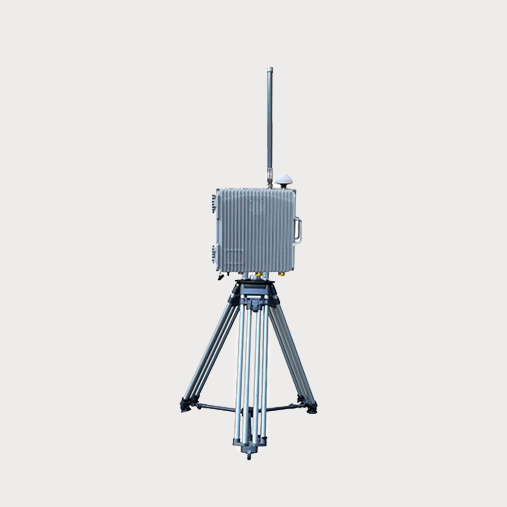
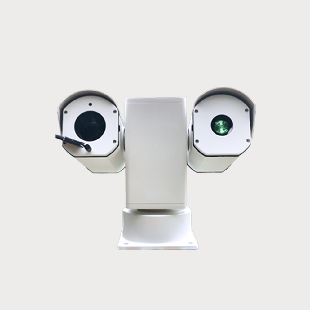
  • Laser light intelligent identification photoelectric has 7*24h monitoring capabilities, which can carry out fully automatic zooming, focusing and optical fog transmission in any weather conditions. It can recognize more than 80 types of targets, such as people, vehicles, ships, etc., and provide accurate target detection and recognition. It integrates intelligent detection, tracking, alerting, and alarming for zoom close-ups and captures of visible light images. Its design supports a wide range of monitoring from 0-360° horizontally and ±90° vertically, making it suitable for close-range target detection and tracking. The system can accurately transmit the azimuth angle and field of view angle of the target, and realize the accurate positioning of moving targets such as drones, vehicles, and ships.
  • $ Inquiry
  • 0 in Stock NowJR-MD1177
  • Group

    JR1177

  • QUANTITY

  • Contact Online

Product introduction: It integrates intelligent detection, tracking, early warning and alarm functions, and can zoom close-up and capture visible light images to provide users with comprehensive security guarantees. Its design supports a wide range of monitoring from 0-360° horizontally and ±90° vertically, making it suitable for close-range target detection and tracking.

Target recognition: It can identify more than 80 types of targets, such as people, vehicles, ships, etc., and provide accurate target detection and recognition.

Identification radius: 1-2KM low, small and slow targets against air, 1-3KM typical targets such as people, vehicles, and ships on land and sea.

Applicable scenarios: It can be quickly deployed to important places in the fields of public safety, power systems, anti-terrorism, military sites, aviation airports, prison guards, event sites, and breeding farms.

You May Be Intersted
Advanced technology system Target range High monitoring accuracy Monitoring distance Strong environmental adaptability Wide range of application

Five-sided array all-round 360-degree detection, the maximum detection distance ≥ 3.0km.

• The phased array system of the radar offers high flexibility and multi-target tracking capabilities. • By controlling the phase of each radiating element, multiple beams can be generated and scanned, enabling the tracking and identification of multiple targets. • Compact and portable, easy to set up, lightweight, and simple to operate. • Maximum detection range is ≥ 3.0km (typical target: DJI "Phantom 3"), depending on the model/environment. • Simple installation and strong usability, with user-friendly terminal software that is easy to learn and use. • High reliability, as the search radar does not require mechanical rotating equipment, avoiding radar work interruptions due to electromechanical failures, thus ensuring higher reliability. • Advanced technology system capable of non-uniform detection, employing different detection schemes for different areas to improve overall detection performance.

$416200
Adaptable Low Cost High Refresh Rate Strong Recognition Ability

The RF scan 3D security radar adopts 3D scanning technology, aiming at the three-coordinate three-dimensional space surveillance of low-altitude, ground targets, all-round and high-elevation coverage

The RF scan 3D security radar adopts 3D scanning technology, aiming at the three-coordinate three-dimensional space surveillance of low-altitude, ground targets, all-round and high-elevation coverage, and is mainly responsible for the real-time reconnaissance of aircraft, ground personnel, vehicles and other targets in the surrounding area, finds and tracks the target, and output or report the target information to the specified user. The radar supports three erection modes: fixed, vehicle-mounted and portable, and is flexibly suitable for various low-altitude and ground security application scenarios.

Inquiry
Strong Penetration Split Screen Display Structural Simulation Reconstruction Multi-target Real-time Positioning

It can penetrate non-metallic obstacles such as building walls, detect multiple personnel targets behind them, and quickly obtain information such as two-dimensional coordinates, number of targets, and indoor structure.

Portable Two Dimentional Positionaing Through Wall Radar 44 is a light and small two-dimensional positioning and penetrating reconnaissance equipment. It can penetrate non-metallic obstacles such as building walls to detect multiple personnel targets behind it, and quickly obtain information such as the 2D coordinates, number of targets, and indoor structure.

$1670
The system realizes low-altitude three-dimensional protection within the diameter of the defense area greater than 10,000 meters JR-HJR1183 UAV frame-side system

It can effectively detect all drones within 10 kilometers, and accurately locate the location and model of the drone. JR-HJR1183 UAV frame-side system

The portable drone detection system can effectively detect all drones within 10 kilometers, and accurately locate the location and model of the drone.

$23600
Active Stereo Monitoring Radar&vision Deep Fusion Dual Spectral Detection  Intelligent Algorithm

Achieve proactive early warning. It has the advantages of high detection accuracy, wide-area 360° panoramic protection, active detection and alarm, high protection level, all-weather/all-weather operation, etc.

40 is a wide-area panoramic security protection product launched for the high-level security requirements of various industries such as judicial, military, petrochemical, electric power, public security, and important ports. With array radar and visual fusion technology, the system can realize intelligent detection of targets in the intrusion area and realize initiative warning. It has the advantages of high detection accuracy, wide-area 360° panoramic protection, active detection and alarm, high protection level and all-day/weather operation.

$43700
Detection distance 18km, with black and white list function, the single machine can display the position of the pilot in real time.

It adopts lightweight design, lightweight and portable, simple operation, and is used for UAV detection and identification, early warning and positioning, and trajectory display

Advantages:Detection distance 18km, with black and white list function, the single machine can display the position of the pilot in real time.

Inquiry
The device's display can provide various information about the drone, such as the drone's model, the frequency bands used, and the drone's signal strength

Artificial intelligence technology, with reconnaissance, direction finding, display and control and networking functions, can effectively detect and identify all kinds of "black flying" UAVs.

The handheld UAV direction finding device integrates spectrum sensing and artificial intelligence technology, with reconnaissance, direction finding, display control and networking functions, and can effectively detect and identify all kinds of "black flight" drones. The device's display can provide a variety of information about the drone, such as the model of the drone, the frequency band used and the strength of the drone's signal. This helps the operator better understand the status and situation of the surrounding drone.

Inquiry
The drone navigation deception system invades the "black flying" drone navigation system by radiating low-power regenerative navigation satellite signals

Effective for most brands of drones, capable of achieving 360 ° all-round defense

The drone navigation deception system invades the "black flying" drone navigation system by radiating low-power regenerative navigation satellite signals, thereby achieving interception and control of drones that need to use navigation systems for flight control, preventing them from flying into protected areas and ensuring low altitude safety in the area.

Inquiry
Shop by Categories